Screens and buttons
Buttons
Section titled “Buttons”The three buttons on the front are called A, B and C from left to right.
| Button | Action | Result |
|---|---|---|
| A | Press | Resynchronizes the time with NTP. |
| B | Press | Switches the map style between “photo” and “twilight zones”. |
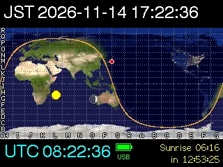
| B | Hold (about 0.7 s) | Cycles the overlay: none → Maidenhead grid → grid and Moon. |
| C | Press | Switches between the map screen and the info screen. |
The map style and overlay are stored on the device and kept when the power is off.
When the screen is dimmed, a button press only lights up the screen and does nothing else. Press the button again once the screen is bright.
Map screen
Section titled “Map screen”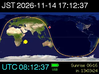
The local time, as “time zone name, year-month-day hour:minute:second”. Set the time zone name and offset with time.tz_label and time.tz_offset_min in config.json.
A world map in equirectangular projection. Its center is your longitude unless map.center_lon is set. The map is redrawn every minute.
| Mark | Meaning |
|---|---|
| Orange line | Grayline (sunrise / sunset line, sun altitude -0.833°) |
| Yellow circle | Subsolar point |
| Red dot | Your location |
| Gray dotted horizontal line | Equator |
Button B switches the map style:
- Photo style (default): NASA Blue Marble by day and NASA Earth at Night (city lights) by night, blended smoothly between sun altitudes of -12° and +2°.
- Twilight zones: day, civil twilight (sun altitude 0° to -6°), nautical twilight (-6° to -12°), astronomical twilight (-12° to -18°) and night in steps of brightness.
Holding button B cycles the overlays:
- Maidenhead grid: dotted lines for each field (20° longitude × 10° latitude), with field letters along the bottom and left edges.
- Moon: the Moon at the sublunar point, drawn with its current phase.
Bottom
Section titled “Bottom”| Item | Meaning |
|---|---|
UTC hh:mm:ss |
Coordinated Universal Time. Cyan when synchronized with NTP, red when not. |
| Battery icon | Battery level in 25% steps (red at 25% or less). A green frame means USB power. The text below shows CHG while charging, USB on USB power, or the level (%) on battery. |
Sunrise / Sunset |
Time of your next sunrise or sunset (local time) and the time left until then. |
Polar night / Midnight sun |
Shown when there is no sunrise or sunset within two days. The second line shows the current sun altitude. |
Info screen
Section titled “Info screen”Press button C to switch.
| Line | Contents |
|---|---|
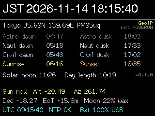
| First line | Your location name, latitude / longitude and 6-character grid locator. At the top right: the location source (config, GeoIP or default) and the reason for the last restart (rst:). |
| Twilight, sunrise, sunset | Morning on the left (start of astronomical, nautical and civil twilight, sunrise) and evening on the right (end of astronomical, nautical and civil twilight, sunset), in local time. --:-- means the event does not happen that day. |
Solar noon / Day length |
Time of solar noon and length of the day. The firmware version is shown at the right. |
Sun now |
Current sun altitude (Alt) and azimuth (Az, clockwise from north). |
Dec / EoT / Moon |
Solar declination (degrees), equation of time (minutes), Moon illumination (%) and whether it is waxing (wax) or waning (wan). |
| Last line | UTC, NTP status (NTP OK or NO SYNC), battery level and power source. |
Screen brightness
Section titled “Screen brightness”The screen is bright (display.brightness) when it is daytime at your location (sun altitude above display.day_alt_deg) and the device is on USB power. At night or on battery, it is dimmed (display.dim_brightness). A button press lights up a dimmed screen for display.wake_sec seconds.
Time synchronization
Section titled “Time synchronization”At startup, the device connects to Wi-Fi and synchronizes the time with NTP. It then disconnects from Wi-Fi and resynchronizes every time.ntp_interval_min minutes (6 hours by default). After a failed sync, it retries every 30 minutes. Press button A to resynchronize right away.
Until the first successful sync, the build time of the firmware is used as a provisional time. In this state, UTC on the map screen is shown in red and the info screen shows NO SYNC.